
Why "Mercator"?
And who we are
Have you seen Google Maps?
The Mercator projection in which they are made is a legacy of the influential Flemish cartographer of the 16th century. Today we continue these traditions.
The Mercator projection in which they are made is a legacy of the influential Flemish cartographer of the 16th century. Today we continue these traditions.
"Mercator" is a tribute to the great professional and a cartographic studio founded by graduates of the Moscow University of Geodesy and Cartography.
There was an idea: to create a production of relief maps made of wood. The kind that no one makes anywhere.
The team, which included woodworking specialists, cartographers, illustrators, artists and modellers, found their calling in this craft.
There was an idea: to create a production of relief maps made of wood. The kind that no one makes anywhere.
The team, which included woodworking specialists, cartographers, illustrators, artists and modellers, found their calling in this craft.
We hand-paint all maps and globes with oil paints. A team of artists works according to the layout approved by the customer, and after that the painting is fixed with varnish.
The color scheme of each product is individual and could be customized to your interior.
The color scheme of each product is individual and could be customized to your interior.
Саймон Симон
Саймон Симон родился в Алшвиле, Швейцария. Изучив рельефное картографирование в Цюрихском институте, Саймон много лет провел в должности военного инженера Швейцарской Федерации. В 1886 г., уйдя с военной службы и углубившись в топографию, он создал несколько выдающихся моделей Швейцарских Альп. Крупнейшая в своем роде модель Бернского нагорья создавалась в течении 28 лет (1886-1914).
Для моделирования ланшафта, при создании карты были обработаны материалы 1700 альпинистских экспедиций, использованы более 10 000 фотографий и несколько тысяч рисунков. Модель впервые была представлена общественности в 1914 г. на Швейцарской национальной выставке в Берне. Сегодня она составляет экспозицию Швейцарского альпийского музея.
Для моделирования ланшафта, при создании карты были обработаны материалы 1700 альпинистских экспедиций, использованы более 10 000 фотографий и несколько тысяч рисунков. Модель впервые была представлена общественности в 1914 г. на Швейцарской национальной выставке в Берне. Сегодня она составляет экспозицию Швейцарского альпийского музея.
History
Art-modeling
The tradition of terrain art-modeling dates back to the 18th century, to the Cartographic Institute of Zurich. Then the need for relief terrain models was dictated not only by scientific, but also by military necessity.
The enormous work of Simon Simon, Xavier Imfeld, Eduard Imhof on modeling the Swiss Alps made them founding fathers of the field, and their works on relief mapping became classics of the genre.
We carefully follow the classics, but apply modern methods and technologies to take our common craft to the new heights.
Ксавьер Имфельд
Ксавьер Имфельд отличался необычайно талантливым и новаторским подходом к своей работе. Руководя работами в области картографии, он также принимал участие в моделировании ландшафтов и строительстве горных железных дорог. Создавая рельефные карты, Имфельд занимался и их продажами: используя инновационный по тем временам метод гальванизации, под его руководством тиражировались модели горных пейзажей.
Однако, две его модели можно считать исключительными. В 1896 году на национальной выставке в Женеве была продемонстрирована "самая красивая модель самой красивой горы мира" — знаменитого Маттерхорна. В разных музеях существуют несколько копий этой модели.
Вторым шедевром стала модель массива Юнгфрау, созданная в течение трех лет (1897-1900) в масштабе 1: 2 500. Служившая для проектирования железной дороги, модель стала украшением Всемирной ярмарки 1900 года в Париже. Временами, более 30 человек занимались изготовлением этого рельефа размером 550 х 450 см. Для моделирования лесного покрова было использовано более 600 000 миниатюрных деревьев.
Имфельд не расписывал свои модели самостоятельно: соавторство принадлежало лучшему картографическому художнику того времени - Фридолину Беккеру. Таким образом, лучший моделлер и лучший художник создали эту фантастическую модель вместе .
Эдуард Имгоф
Одними из самых известных на сегодняшний день гипсовых моделей являются работы Эдуарда Имхофа – основателя картографического института в Цюрихе. Две монументальные крупномасштабные гипсовые модели горных массивов Бичхорн и Гросс-Винтергле были показаны на Швейцарской национальной выставке 1939 г. Модели, воспроизводящие острые скальные гребни в блестящем качестве, выполнены в масштабе 1: 2000 и имеют размеры 170 x 137 см и 307 x 163 см соответственно. Колоссальная работа по их созданию была проведена профессором за полтора года, а при создании были использованы тысячи аэрофотоснимов и фотограмметрических изображений, полученных специально для этого проекта.
The model created by Simon Simon in 1886-1914 was the largest relief map of Swiss Alps during a long time. Being 480 x 525 cm, it covered 25m² area.
Grindelwald is also the area in Bernese Highlands. The photo shows its embodiment in Xavier Imfeld's relief model.
The mountain range of Central Switzerland was the first work of Eduard Imhof - the most famous Swiss cartographer, the founder of Zurich Institute of Cartography.
At that time, terrain models have been creating by hand, from plaster, wood, cardboard and other materials.
Many years of work by many engineers required to replicate the terrain accurately.
The paint was applied to the model using an airbrush.
Many years of work by many engineers required to replicate the terrain accurately.
The paint was applied to the model using an airbrush.
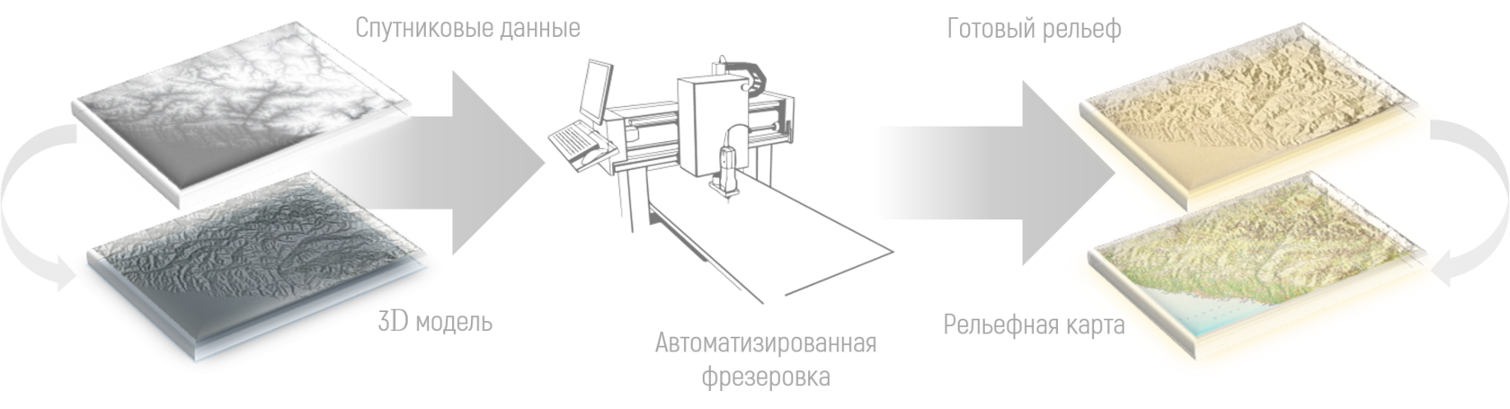
Today we create relief maps using elevation data from satellites.
Automated equipment is responsible for accurately reproducing the wooden model.
Automated equipment is responsible for accurately reproducing the wooden model.
We make frames for our maps using premium species of wood: North American walnut, sapele mahogany or ash.
To ensure that our products have minimal weight, we use abacha wood for our maps.
To ensure that our products have minimal weight, we use abacha wood for our maps.
Today we create maps of any size, scale, for any territory, in any language.
Flexibility is the main principle in our work.
Flexibility is the main principle in our work.
The maps we create, like many years ago, are painted by hand: with a brush and oil paints. And the high accuracy of models is achieved using modern geoinformation technologies and equipment with numerical control.
This allows us to reproduce the relief of the Earth's surface reliably, using both paper maps and satellite or geodetic survey materials.
This allows us to reproduce the relief of the Earth's surface reliably, using both paper maps and satellite or geodetic survey materials.
Each map is precisely made of solid wood according to a 3D model. Multi-stage finishing allows you to mark exceptionally small details in the wood.
Your map:
To order a unique map, contact us on WhatsApp or fill out the form below:
Contacts:
+7 (993) 292 22 07
maps.mercator@gmail.com
maps.mercator@gmail.com
st. Druzhby, 19
Dubna
INN: 501004625866
OGRNIP: 318500700049461
Dubna
INN: 501004625866
OGRNIP: 318500700049461